|
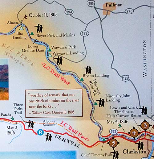
For most of the Lewis and Clark Trail the outbound (1805 west)
and inbound (1806 east) coincide. In some cases they are many hundred
miles apart. In eastern Washington they separate by several miles;
but they are close enough to cover both with a little extra driving
and route finding. Clarkston is the place to make this choice or
to choose outbound or inbound. If you choose the first you will
want to skip the detour from US HWY 12 out of Clarkston, down the
Snake River.
The detour requires taking WA HWY 193 in Clarkston. Take the Red
Wolf Crossing bridge northwest to several Lewis and Clark Trail
interpretive sites along the north side of the river. See images
of the bridge on lct238. The four sites
along Hwys 193 & 194 follow the Corps's Oct. 11, 1805 float
down the Snake River. After reaching Almota, return to US HWY 12
and drive west to Chief Timothy State Park.
Both trails meet at Chief Timothy State Park. In fact outbound and
inbound trails meet here and at the confluence of the Walla Walla
River and the Columbia River south of Pasco. The Corps passed by
the park area on October 11, 1805 by canoe and on May 4, 1806 by
horse. They passed by the Walla Walla River on October 18, 1805,
heading west, and camped there on April 29, 1806 on the return journey.
The inbound trail, and the lower Snake River section of the outbound
trail, can be covered by driving an irregular oval route from east
to west or west to east. The "Two Roads" map on the next
page shows the main roads of the route. Look for detailed directions
on the following pages. Be sure to use the "back" arrow
to return to your trail page.
|