|
|
| MT
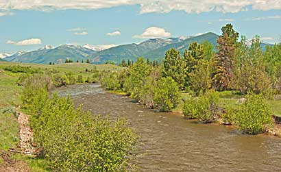
HWY 200 fellows close to Monture ("Seaman") Creek. A short
walk across a meadow, top right, presents pleasant views of its meandering
run. Monture Creek's origin, wanders from several miles northeast
of Ovando, flowing south to meet Blackfoot River, from the right,
above, near HWY 200. National Geographic's Guide to The Lewis &
Clark Trail by Thomas Schmidt described this Monture (Seaman) Creek
area: "... a bend of Monture Creek slips around a small meadow
... and undercuts a hillside topped with ponderosa pine." I couldn't
have said it better. |
|
|