|
|
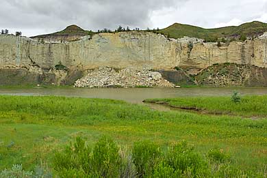
| Eagle
Rock, above, appears on the north bank of the Missouri, before arriving
at Eagle Creek, top left and left. I believe Eagle Rock is an unofficial
name - it does look vaguely like a perched eagle. Traveling down river,
as we did, you would pass Eagle Creek, coming in from the north, first.
The Corps pulled in at Eagle Creek and made camp on May 31st, 1805.
Captain Lewis marveled at the high cliffs across the Missouri from
the campsite: "...on the top is a dark rich loam, which forms
a gradually ascending plain...when the hills again rise abruptly to
the height of about 300 feet more." Later, Lewis comments on
his approach to Eagle Creek: At the distance of 2 1/2 miles from the
last stone wall is a stream on the north side, 28 yards in width,
and with some running water. We camped just above its mouth, having
made 18 miles [from the last camp]." |
|
|