 |
 |
 |
 |
 |
| Umatilla Oregon |
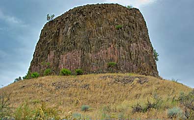
| The interpretive signs cover much of the Corps's activities in the area. A map of the native villages along the Columbia at the time is enlightening. A section of that map is on the previous page. Note some of the Indian place names next to the English ones. Hat Rock's west face, top left. The view on the previous page is closer to what Captain Clark saw. |
| Lewis & Clark Trail |
| lc main page | maps |