|
From the Russell NWR I opted to continue south west on US HWY 191
to MT HWYs 81 and 80, turning north west to Ft. Benton where the
highway crossed the Missouri. I bypassed a few gravel roads into
the Missouri Breaks, choosing to pick up the L&C Trail at the
Missouri-Marias Rivers confluence (see map on next page).
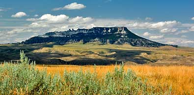
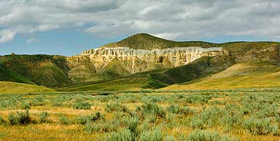
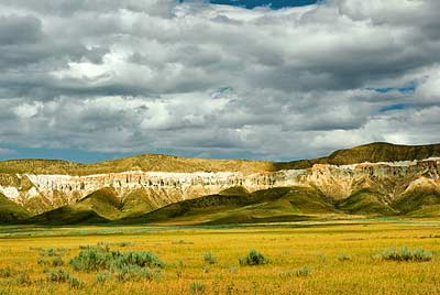
A few miles south of Geraldine, on HWY 80, you can view the south
side of some of the geological formations that gave the White Cliffs
of the Missouri Breaks its name, left and top right. Also, across
the highway, to the west, stands another unique geological creation
- Square Butte (5703 ft.). On June 4th, 1805 Captain Lewis noticed
its shape from a high vantage point above the Marias River 30+ miles
north of here. He wrote: "Barn Mountain, a lofty mountain so
called from it's resemblance to the roof of a large Barn, is a seperate
Mountain and appears reather to the wright of and retreating from
the extremity of the S. mts. (Highwoods). ; this boar S. 38 W. distant
35 ms." Ella Mae Howard, in Lewis &
Clark: Exploration of Central Montana,
points out that Barn Mountain is really south east of where Lewis
observed it.
|